Johnny Cash
Country music legend Johnny Cash was born February 26, 1932 in the Cross Roads community north of Kingsland to Ray Cash and Carrie Cloveree Rivers. He was the fourth of seven children, who were in birth order: Roy, Margaret Louise, Jack, Johnny, Reba, Joanne, and Tommy. Though he left Cleveland County at the age of three to move to the Dyess Colony in Mississippi County in Northeast Arkansas, “J.R.” (as he was known locally) often returned to the county to visit relatives at both Kingsland and Rison.
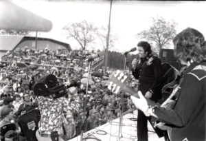
Even at the height of his fame, Cash, along with his wife June Carter, would make trips back here to attend family reunions often undetected by the general public. He made two promoted visits to Cleveland County, once in 1976 to hold a Bicentennial Concert at the Rison High School football field (attended by an estimated 10,000 people, making it the largest event ever held in Cleveland County), and in 1994 to commemorate his U.S. Postal Service stamp at the Kingsland Post Office.
For more information about Cash, or to visit his museum, click here.
Directions:
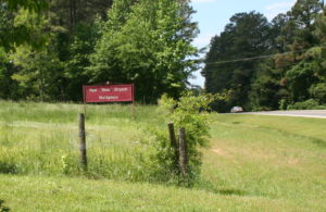
- Welcome To Kingsland: Birthplace of Johnny Cash – North Sign
- Welcome To Kingsland: Birthplace of Johnny Cash – South Sign
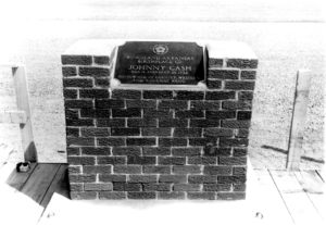
- Johnny Cash Monument
- Johnny Cash’s Birthplace
Follow the Johnny Cash Self-Guided Tour Narrated by Rosanne Cash
Stop 1: Birthplace Marker
Stop 2: Johnny Returns To Kingsland Marker
Stop 3: Johnny Cash Day in Arkansas / Johnny Cash 1976 Concert Marker
Stop 4: Cash Family Reunions Marker
Saline River
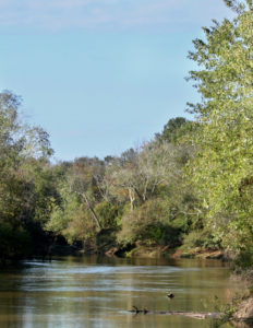
The Saline River criss-crosses Cleveland County from northwest to southeast. It is the last major undammed stream in the entire Ouachita Mountain drainage, offering excellent fishing, scenery and backcountry floating. The Saline remains relatively unspoiled by man and creates an illusion of wilderness along much of its length. Dense forests line the river banks. Visitors may be treated to the sight of deer, mink, otters, beaver, muskrats and a variety of bird species. For more information, visit the Arkansas Tourism website.
Paul “Bear” Bryant
Legendary college football coach Paul “Bear” Bryant was the 11th of 12 children who were born to Wilson Monroe and Ida Kilgore Bryant in Moro Bottom, near the Smith Chapel community in Southwest Cleveland County. He attended high school at Fordyce in neighboring Dallas County. He earned his famous nickname by wrestling a bear at a traveling carnival passing through Fordyce when he was 13. Bryant went on to earn fame as one of the greatest college football coaches in history after winning six national championships and 13 conference champions at the University of Alabama.
Directions: click here.
Kingsland Prairie Natural Area
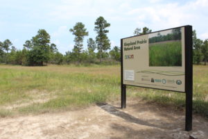
Courtesy of the Arkansas Natural Heritage Commission: Kingsland Prairie Natural Area, located in the Coastal Plain, consists of a mosaic of salt slicks, saline barrens, mound woodlands, pine savanna, and bottomland hardwood forest communities. Soils at the site, containing high amounts of sodium and magnesium salts, account for the sparse and irregular distribution of trees and the resultant dominance of grasses and other herbaceous vegetation in the barrens and associated woodlands. The unique soils and sparse tree cover create ideal habitat for a number of rare herbaceous plant species including the federally threatened species Geocarpon minimum. Numerous shallow, seasonally-wet depressions in the barrens also provide for a rich diversity of plant species. The Nature Conservancy (TNC) owns property contiguous with the natural area.
Directions: click here.
Marks Mill Battleground State Park
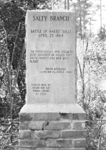
The most lopsided victory of any American Civil War battle west of the Mississippi River took place near John H. Marks mill in what is now Southeast Cleveland County, near New Edinburg. On April 25, 1864, as a Union wagon train slowly made its way to Pine Bluff through virtually impassible mud, Confederate General Edmund Kirby Smith assembled an attack force of several thousand men intercepted the wagon train at Marks’ Mill. Nearly all Union survivors were captured and essentially brought an end to the Union’s Red River Campaign. The historic site is southeast of Fordyce at the junction of Ark. 97 and Ark. 8. For more information, visit the Arkansas State Parks website.
Directions to the State Park: click here.
Visitors can also see a collection of private monuments, including a memorial to all those killed in the battle, at the nearby historic Marks’ Cemetery. The cemetery is located approximately two miles from the state park.
Directions from the state park: Click here, or take Hwy. 97 north approximately one mile to Marks Cemetery Road on the right (look for marker on the left side of the highway), follow Marks Cemetery Road approximately a half mile, then turn right onto Old Camden Road (the entrance will be well marked).
Pioneer Village at Rison
The Pioneer Village at Rison is a collection of historic structures from Cleveland County dating back to the mid-to-late 1800s. The grounds include the historic Mt. Olivet Methodist Church, the Mercantile and the Dr. McMurtrey house, the home of one of Cleveland County’s earliest physicians. In addition, the Pioneer Village is also the home of the Rison Community Garden, a “training” garden consisting of 27 raised beds, high tunnel, compost corral and demonstration gardens. The community garden serves as the headquarters for the Arkansas Homesteading Conference.
Directions: click here.